David Thompson’s Travels
.jpg)
The information in the following article come primarily from the great geographer, astronomer and mapmaker David Thompson’s daily journals (1784 to 1812) and his later interpretation of these journals into what is known as his narrative.
David Thompson was of Welsh parents, born in Westminster on April 30, 1770. His father died on February 28, 1772, leaving Mrs. Thompson with two small boys under two years of age. In 1777 David was taken off her hands and placed in a charity school near Westminster Abbey. This was called the Gray Coat school which Thompson describes as “a royal foundation” where “I received a mathematical education for the Royal Navy.” But he continues “the peace of 1783 and the reduction of the Navy did not require us and my lot fell to be engaged by the Hudson Bay Company.” He apprenticed to the Hudson Bay Company for seven years.
On May 29th, 1784, he sailed from the Thames on the Prince Rupert and arrived at Churchill factory in Hudson Bay in September of 1784. There Thompson’s career in North America began. He spent one year at Churchill under the factor Samuel Hearne after which he was sent in 1785 to York Factory.
In that same year of 1785 he went inland with William Tomison and remained there until 1791. Two important things happened during his long stay inland. The first was that Thompson had a serious accident, breaking his leg on Dec. 23, 1788. The following winter at Cumberland House, a H.B.C. post on the Saskatchewan River, Tomison’s journal records “David Thompson’s leg still bad.” The second thing was, that as a result of this accident at Cumberland House, his future career was decided and possibly had a major impact on the history of Western North America.
Philip Turnor, the H.B.C. surveyor and astronomer also wintered at Cumberland House over the winter of 1789-1790. During this period, he trained both Peter Fidler and David Thompson in the art of surveying, astronomy and mapmaking. This training later made Thompson know to the First Nations west of the mountains as “Koo-Koo-Sint” which appears to be a salish word for starts and probably meant “The Star Man.”
Thompson served thirteen years with the Hudson Bay Company and became quite disillusioned by what he considered their lack of interest in exploring and mapping new lands to the west. He was concerned that their interest lay solely in the profit derived from trading furs with the First Nation people.
On the 9th of June, 1797 he made an entry in his journal, “Today I left the service of the Hudson Bay Company and joined that of the Northwest Company of Canada.”
Several historians question Thompson’s rationale in this decision, but despite the controversy the fact remains that he did leave the service of the Hudson Bay Company and join the rival Northwest Company of Canada. While it does not appear to have had any impact on Thompson’s decision, the fact that the Hudson Bay Company was headquartered in London, England, whereas the Northwest Company of Canada was headquartered in Montreal may have had an influence on the difference in attitude of the two companies.
The Northwest Company immediately sent him on a major surveying and mapping expedition on which he traveled over 3000 miles and was shown much appreciation by his new employer.
His surveying, fur trading, and exploring took him further west and eventually in the spring of 1800 we find Thompson and the N.W.C. factor, Duncan McGillivary, on the upper Saskatchewan River at Rocky Mountain House. The assignment was to find a suitable trade route through the mountains and a navbigatable waterway to the western ocean.
In the fall of 1800 after exploring the present day Bow River (from Calgary to west of Exshaw) for an access route across the mountains, they were returning north to Rocky Mountain House, when they were advised by a camp of Piegan First Nations that a group of Kootenai First Nations people from across the mountains were camped on the upper reaches of the Red Deer River. Thompson turned west up the Red Deer to try to make contact with these visitors from the west side of the mountains. He eventually met them about 25 miles west of the present community of Sundre, Alberta. This group of Kootenai’s consisted of twenty-six men and seven women. They complained bitterly of the constant harassment and horse stealing by the Piegans, who had firearms and could dominate the natives from the west, since they had no access to the white mans trading posts.
Thompson convinced the Kootenais to come with him back down the Red Deer and north to the trading post at Rocky Mountain House. While trading with the Kootenais, Thompson carefully questioned them about their country and any major rivers over the mountains. He convinced them to take two of his men, La Gasse and Le Blanc, back over the mountains to winter with them at what we now know as the headwaters of the Columbia River. He gave them some of his horses to assist them in their journey. This group left Rocky Mountain House on 21st October, 1800.
La Gasse and Le Blanc returned down the Columbia, up the Blaeberry, over Howse Pass and down to Rocky Mountain House the following spring arriving at Rocky Mountain House in May of 1801.
Thus these two men, La Gasse and Le Blanc were, in late October or early November of 1800, the first non-aboriginal people to cross the mountains to the Columbia River and pass by the locality of the place we now call home.
The priorities of the fur trade turned eastward and the Columbia River was not visited again until 1806, when Jaco Finlay, with his family and small crew of men, was sent across to clear the trail over Howse Pass and down the Blaeberry River to the Columbia where he was to build several canoes. Finlay was employed for this task to prepare the way for Thompson and his party who came over in the spring of 1807. Thus Jaco Finlay became the second non-aboriginal visitor to our fair valley.
Now came the mighty explorer and mapmaker himself, David Thompson. On the 10th of May, 1807, laden with canoes and horses for transportation, a total of fourteen people, accompanied Thompson as he left Rocky Mountain House including his wife, Charlotte (nee Small) and family, and Finan MacDonald, his chief clerk.
Just west of the present bridge across the Saskatchewan River on the Banff Jasper Highway they had to abandon their canoes and transfer their goods to the horses. Snow on Howse Pass delayed them further and finally at 5:00 am, on 25th of June, 1807, they left the Saskatchewan. By 1:00 pm on the same day they reached the height of land where Thompson observed a small stream of water running to the west. Being a religious man he records in his journal “May God in his mercy give me to see where these waters flow into the western ocean.”
The party travelled with great difficulty over the trail cut by Jaco Finlay the previous year. They were also desperately short of food. He describes what we now call Howse Pass as “the height of land” and the Blaeberry Valley as “the Portage.”
By the 30th of June, 1807 the party had reached what he calls the “Kootenai River” (present day Columbia) and made a camp on the south end of what we now know as Moberly Marsh. They dried their trade goods, sent hunters looking for game, built canoes, (the canoes Finlay built were useless) and on July 12th, having placed all the goods in three canoes proceeded up the river. Thompson’s journal records many items of interest, however, two names he gave to the features are descriptive. While passing the present day Kicking Horse River he called it the, “Rapid River,” and a mile further south he ventured onto a large lake on the west side of the river where he shot 9 swans and hence named the body of water “Swan Lake.” This area today is known as McBeath slough or Cedar slough.
The party reached the lower Columbia Lake by the 18th of July, 1807, and after a bad start further up the lake constructed the trading post we know as Kootenai House just west of the present town of Athalmere. This trading post and accompanying structures was the first trading post erected by white men up the waters of the Columbia River, ante-dating the first erected by an American trader, Andrew Henry, on the headwaters of the Snake River by three years.
The Piegans on the east side of the mountains made a determined effort to destroy Kootenay House and its inhabitants. They were successfully repulsed with no bloodshed. While at Kootenay House that winter Thompson surveyed and named Mt. Nelson, a peak southwest of the house. The name stands at Mt. Nelson on today’s maps of the area.
On the 20th of April, 1808 he went south as far as present day Bonners Ferry in Idaho, and on his return reached Kootenay House by the 5th of June. From here, taking his family and the winter fur with him, he again passed by our present homes, reaching the Kootenay Plains on June 22nd. at Boggy Hill on the Saskatchewan River, he left his family and continued all the way east to Rainy Lake House which is east of Lake Winnipeg. Two days later he set out on his return journey westward towards Kootenay House where he arrived on the 10th of Nov., 1808.
Thompson made the same journey across the mountains with furs in 1809 and returned with trade goods. On the east side of the mountains he met Joseph Howse, a clerk of the Hudson Bay Company, on an exploration trip. Howse was returning to the east, and he had not crossed “the height of land.”
On this return trip in 1809 Thompson continued south to the present station of Woolin on the Northern Pacific Railway where he built the trading post called Salish House; here he spent the winter of 1809-18100. In the spring of 1810 he and his employee’s gathered numerous packs of furs from the various trading posts on the tributaries of the Columbia south of what is now the American border. On the 9th of May, 1810 he left Kullyspell House for the Kootenay River and on the 17th of May, accompanied by his old chief clerk, MacMillan, started up the river with his brigade of canoes reaching McGillivary’s portage (Canal Flats) on June 6th. He came down the Columbia, passed our village again, on his last journey eastward over the Mountain Portage where he arrived on the Saskatchewan by June 19th.
It was in 1810 that Joseph Howse came west over the “Mountain Portage” and established a trading post on what was then known as Flathead Lake.
In late September Thompson started west up the Saskatchewan again with the intention of crossing the height of land by the Mountain Portage (Howse Pass and the Blaeberry). He sent his canoes ahead while he rode up the valley of the Saskatchewan on horseback to the foot of the mountains, but as his canoes had been intercepted and turned back by the hostile Piegans, he was obliged to return down the river and find a new trail to the Columbia River.
Thompson headed to Athabasca Pass situated at the headquarters of the Athabasca River which was north of the hostile Piegan territory. They ascended with horses and on the 29th of December, 1810, set out with dog sleds and four horses to cross the mountains by this alternate route. The horses were soon sent back due to the heavy snow.
After a very difficult journey they reached the Columbia River at Boat Encampment on January 18, 1811. At this point several of the men deserted and returned to the Athabasca River. Thompson and three men remained, built a cabin, shot eleven moose, and spent the winter building a chinker built cedar strip canoe which they launched for their journey up the river on the 17th of April, 1811. The exact date the party passed our fair city is not known but he does record reaching the head of the Columbia Lake on the 14th of May, 1811.
This is the last time the great explorer and fur trader was to pass the place now known as Golden, BC.
Athabasca Pass was used for many years by the North West Company and later by the Hudson Bay Company as their main line of travel from the great plains to the valley of the Columbia River. It is interesting to note that Alexander Henry, of North West Company, and a working partner of David Thompson, came through Howse Pass, and down the Blaeberry from the east in 1811, despite the hostility of the Piegan First Nations. He brought with him trade goods for the posts on the lower Columbia. He was the last of the early explorers who came that route to pass through our valley.
The Piegans on the east side continued to be hostile to any fur traders trying to get through the Saskatchewan, Howse Pass, and the Blaeberry to trade guns with the Ktunaxa.
For the remainder of the summer of 1811, Thompson, continued his explorations down the Columbia and its tributaries until at 1:00 pm on the 15th of July, 1811 his prayer of July 25, 1807, at “the height of land” was answered for he had arrived at the western ocean to find Fort Astoria, a trading post, newly built by the American Pacific Fur Company, who had come by ship around the horn.
After spending a few days at Astoria where he was made welcome, Thomson started back up the Columbia. On this journey up the river he did not go north by way of the Kootenay, but rather went by the more direct route of the Columbia River, passing the mouth of the Kootenay River, camped at the present site of Castlegar, through the two Arrow Lakes, by the site of Revelstoke and finally arrived at his hut at Boat Encampment on September 18t, 1811.
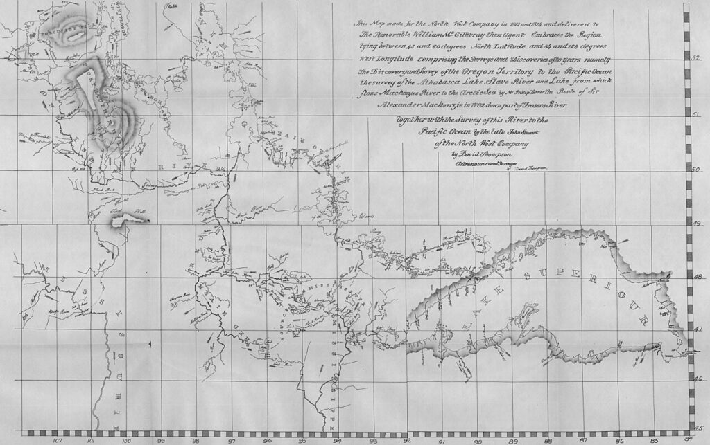
He had now traveled over and surveyed the Columbia River from source to ocean. The remainder of 1811 until April of 1812, he bade good bye to the posts on the Columbia and reached Boat Encampment for the journey east which was to take him to his family, civilization and retirement. “Thus I have fully completed the survey of this part of North America from sea to sea, and by almost innumerable astronomical observations have determined the positions of the mountains, lakes and rivers, and other remarkable places on the northern part of this continent; the maps of all of which have been drawn, and laid down in geographical position, being now the work of twenty seven years.”
One cannot help but wonder, if in all his travels he did remember a special area n the Columbia River; a place we now call home. “The Upper Columbia.” It is quite possible since he did name the river that runs through hour community the “Rapid River,” and the backwater southeast of town “Swan Lake.” Not many places in all his travels received such special consideration.
On May 8th, 1812 Thompson crossed “the Height of Land,” down the Athabasca River and the long journey to the east. He gathered Charlotte and family on the way, (Charlotte bore him seven sons and six daughters) and as J.B. Tyrell, the great historian describes it, “In early September arrived at Terrebonne, north of Montreal. Here he took up his residence; and although in the course of his survey of the boundary line between the United States and Canada he travelled as far west as Lake of the Woods, he never returned to his old fields of labour in the far west, or revisited any of his early homes on the banks of the Saskatchewan or Columbia Rivers.”